


MIAMI (AP) — A storm without a name and unusual king tides were causing some flooding on the Carolina coast early Friday as tropical storms churned in the Atlantic and along Mexico’s Pacific coast.
About a dozen streets were already flooded in Charleston, South Carolina, and the city offered free parking in some garages. A high tide of 8.5 feet (2.6 meters) was forecast Friday morning, which would be the 13th highest in more than a century of recorded data in Charleston Harbor.
The unnamed coastal storm and unusually high king tides, when the moon is closer than usual to the Earth, threatened to bring days of heavy winds that could cause coastal flooding, especially along the vulnerable Outer Banks of North Carolina and around Charleston.
Along the Outer Banks, forecasters said the worst weather should occur Friday through the weekend. They warned it was likely that highway N.C. 12 on Hatteras and Ocracoke islands would likely have to close again because of ocean overwash.
In the Pacific, Tropical Storms Priscilla and Raymond threatened heavy rain along the Mexican coast, and Priscilla could cause flash flooding across the U.S. Southwest through the weekend. Flood watches were issued for parts of Arizona, California and Nevada.
Priscilla was centered about 190 miles (300 kilometers) west-northwest of Cabo San Lazaro, Mexico, and moving north at 6 mph (9 kph) with maximum sustained winds of about 50 mph (85 kph).
A tropical storm warning associated with Raymond was issued from Zihuatanejo to Cabo Corrientes, Mexico. Raymond was forecast to remain off the southwestern coast of Mexico through Friday before nearing Baja California Sur on Saturday and Sunday.
Raymond was about 95 miles (150 kilometers) south-southeast of Zihuatanejo, Mexico. It had maximum sustained winds of 50 mph (80 kph) and was moving west-northwest at 15 mph (24 kph), forecasters said.
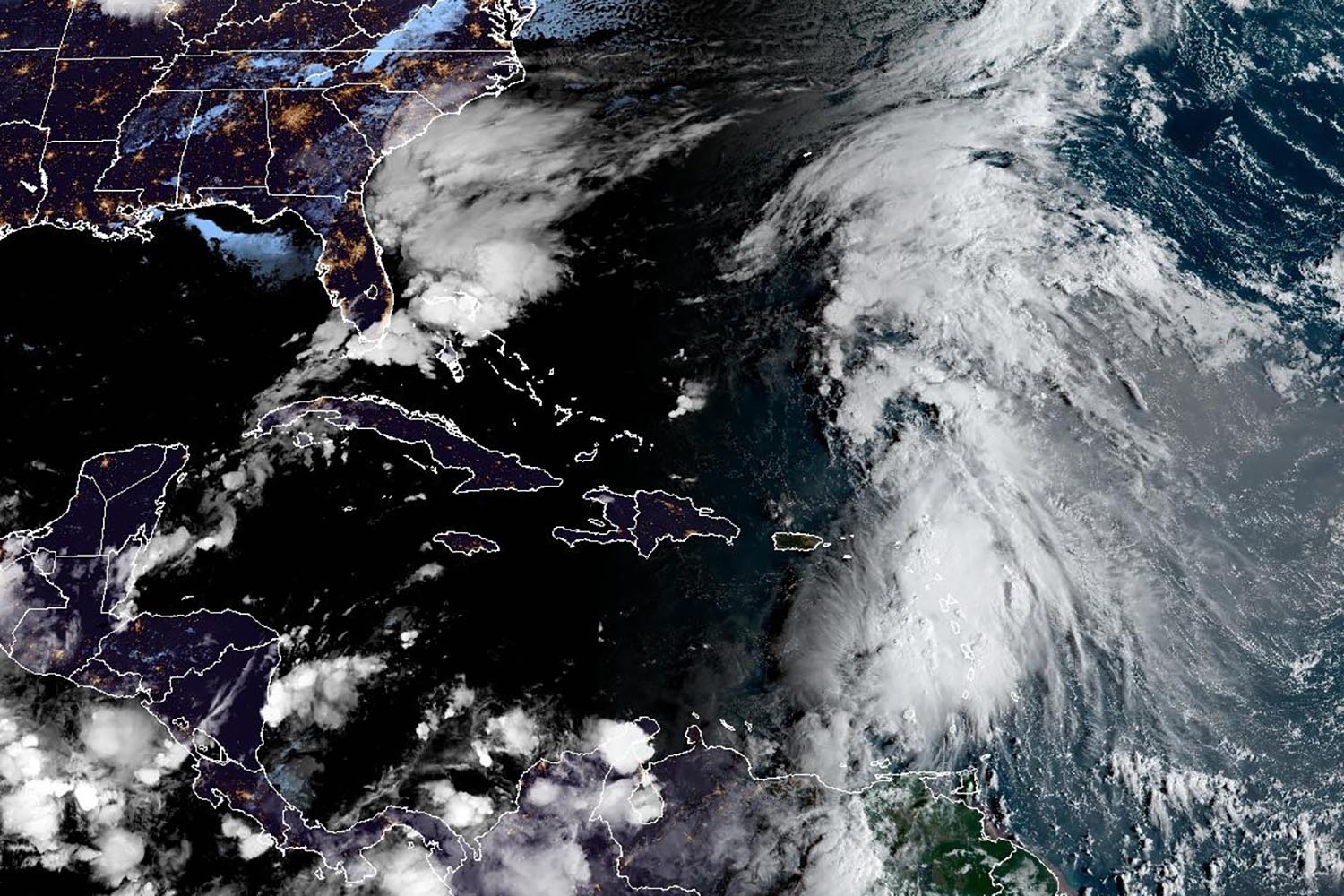
In the Atlantic, Jerry was passing east of the northern Leeward Islands and causing heavy rainfall. Officials in Guadeloupe warned of potential power outages.
Jerry was centered about 65 miles (100 kilometers) east-northeast of the northern Leeward Islands and moving northwest at 16 mph (26 kph) with maximum sustained winds of 60 mph (95 kph).
A tropical storm warning was in effect for Barbuda and Anguilla, St. Barthelemy and St. Martin, Sint Maarten and Guadeloupe and the adjacent islands. A tropical storm watch was in effect for Antigua, St. Kitts, Nevis and Montserrat and Saba and St. Eustatius, the hurricane center said.
The storm should strengthen into a hurricane Saturday. The Nor’easter expected to send rain and pounding waves into the Southeast U.S. is helping steer Jerry away from the islands and into the open Atlantic, forecasters said.
Also Thursday, Subtropical Storm Karen formed far from land in the north Atlantic Ocean. Karen had maximum sustained winds of 45 mph (75 kph) and was expected to maintain that strength through the day.
A subtropical storm tends to have a wide zone of strong winds farther from its center compared to a tropical storm, which generates heavier rains, according to the U.S. National Weather Service.
About seven weeks remain in the 2025 Atlantic hurricane season, and meteorologists warned the Pacific Ocean cooling pattern called La Nina, which can warp weather worldwide and turbocharge hurricanes, has returned.
It may be too late in the hurricane season to impact tropical weather in the Atlantic, but this La Nina may have other impacts from heavy rains to drought across the globe.